We have compiled a list of manufacturers, distributors, product information, reference prices, and rankings for Survey drone.
ipros is IPROS GMS IPROS One of the largest technical database sites in Japan that collects information on.

Survey drone Product List and Ranking from 6 Manufacturers, Suppliers and Companies | IPROS GMS

Last Updated: Aggregation Period:Aug 19, 2026~Sep 15, 2026
This ranking is based on the number of page views on our site.

Survey drone Manufacturer, Suppliers and Company Rankings

Last Updated: Aggregation Period:Aug 19, 2026~Sep 15, 2026
This ranking is based on the number of page views on our site.

  1. 横浜測器 本社 Kanagawa//Trading company/Wholesale
  2. アイティーシム Kanagawa//Trading company/Wholesale
  3. 株式会社快適空間FC Fukuoka//environment
  4. 4 芝本産業 東京本社 Tokyo//Industrial Machinery
  5. 5 ブルーイノベーション Tokyo//robot

Survey drone Product ranking

Last Updated: Aggregation Period:Aug 19, 2026~Sep 15, 2026
This ranking is based on the number of page views on our site.

  1. AEROSENSE Inc. AEROBO 横浜測器 本社
  2. Aerial photography and surveying drone "INSPIRE 2" 株式会社快適空間FC
  3. Ishikawa Energy Research's 【Build Flyer】 アイティーシム
  4. Domestic Drone: Aerobo (AS-MC03) 横浜測器 本社
  5. 3DR Site Scan 芝本産業 東京本社

Survey drone Product List

1~13 item / All 13 items

Displayed results

Aerial photography and surveying drone "INSPIRE 2"

Inherit the functions of INSPIRE 1 and enhance safety, reliability, and intelligent features.

The "INSPIRE 2" inherits the features of INSPIRE 1 and enhances safety, reliability, and intelligent functions. The intelligent flight control system monitors the redundant systems and provides accurate flight data. Additionally, the new image processing system supports Adobe Cinema DNG RAW, Apple ProRes, and can capture video up to a maximum of 5.2K. 【Features】 ■ Improved reliability through redundancy ■ Vision positioning and obstacle detection and avoidance functions ■ Higher image quality with even greater detail *For more details, please download the PDF or feel free to contact us.

  • Distance measuring device
  • Other measurement, recording and measuring instruments
  • Survey drone

Added to bookmarks

Bookmarks list

Bookmark has been removed

Bookmarks list

You can't add any more bookmarks

By registering as a member, you can increase the number of bookmarks you can save and organize them with labels.

Free membership registration

3DR Site Scan

A cloud solution that simplifies on-site work to improve efficiency!

By using Site Scan, you can perform tasks six times faster compared to traditional surveying (detailed examples are introduced on our company website!). Site Scan includes everything needed for drone surveying and inspections: the main unit, camera, flight app, and management software for data processing. Data processing and management are done through cloud software, so users' computers are not tied up for long periods. Additionally, users who are granted access to the cloud can access information anytime and from anywhere via the internet. Moreover, with drones equipped with high-resolution cameras, it is possible to achieve millimeter-level accuracy! 【Benefits】 ■Efficiency: Specialized tasks performed on-site can be centrally managed remotely. ■Time-saving: Time is reduced through fully automated processing from shooting to analysis. ■Simplification: Cost reduction including security and system management. ■Streamlining: Smooth data sharing among stakeholders. *For more details, please download the PDF or feel free to contact us.

  • Color camera
  • Distance measuring device
  • Survey drone

Added to bookmarks

Bookmarks list

Bookmark has been removed

Bookmarks list

You can't add any more bookmarks

By registering as a member, you can increase the number of bookmarks you can save and organize them with labels.

Free membership registration

High-precision 3D map of scanned spatial information from ELIOS 3

Display in real-time! Instantly grasp location information and the surrounding environment.

"ELIOS 3" is a powerful "flying data collection device." The spatial information scanned by the LiDAR sensor is displayed in real-time as a high-precision 3D map, allowing for instant awareness of the product's location and surrounding environment. With the stable flight algorithm created by the SLAM engine, pilots can achieve complex missions with minimal training. [Features (partial)] ■ FlyAware(TM) SLAM engine ■ Stable flight using SLAM technology ■ Real-time 3D map ■ 3D report ■ 3D surveying solution ■ Modular payload bay *For more details, please refer to the PDF document or feel free to contact us.

  • Remote Control
  • Survey drone

Added to bookmarks

Bookmarks list

Bookmark has been removed

Bookmarks list

You can't add any more bookmarks

By registering as a member, you can increase the number of bookmarks you can save and organize them with labels.

Free membership registration

AEROSENSE Inc. AEROBO

Technology that supports society from the sky. Introducing the Japanese-made drone 'AEROBO'!

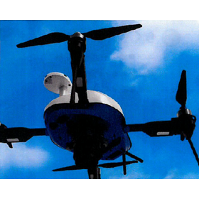
Yokohama Instruments handles AeroSense's "AEROBO." Specialized for surveying and inspection applications, it is equipped with a high-resolution camera. It achieves automatic takeoff and landing, as well as autonomous flight, based on a unique flight plan, and can be expanded in various ways according to applications, including infrared sensors and spectral cameras. Additionally, we offer GNSS surveying equipment such as "AEROBO MARKER" and "AEROBO CLOUD." 【Features of AEROBO】 ■ Japanese-made drone enabling high-precision measurement and analysis ■ Specialized for surveying and inspection applications ■ Equipped with a high-resolution camera ■ Capable of various expansions according to applications *For more details, please refer to the PDF document or feel free to contact us.

  • others
  • Survey drone

Added to bookmarks

Bookmarks list

Bookmark has been removed

Bookmarks list

You can't add any more bookmarks

By registering as a member, you can increase the number of bookmarks you can save and organize them with labels.

Free membership registration

[Drone] New Aero Robotic PPK (AS-MC03-PPKHL)

2-frequency GNSS receiver equipped for post-processed kinematic surveying.

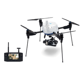
The "New AeroBot PPK" achieves long-distance communication performance by adopting Herelink HD Transmission. It allows for "checking the camera footage during flight" and "taking completion photos from any angle by operating the gimbal" on the control terminal, significantly enhancing convenience. 【Features of the New AeroBot PPK】 ■ Equipped with a dual-frequency GNSS receiver ■ Adopts Herelink HD Transmission ■ Features quick attachment *For more details, please refer to the PDF document or feel free to contact us.

  • others
  • Survey drone

Added to bookmarks

Bookmarks list

Bookmark has been removed

Bookmarks list

You can't add any more bookmarks

By registering as a member, you can increase the number of bookmarks you can save and organize them with labels.

Free membership registration

Domestic Drone: Aerobo PPK (AS-MC03-PPK)

GNSS receiver with dual-frequency support for post-processed kinematic surveying.

The "AeroRob PPK" is a domestically developed drone specifically designed for photogrammetry, created to reduce the labor involved in installing ground control points during the photogrammetry process. It allows for photogrammetry to be conducted without the need to set up reference points, making it particularly recommended for daily applications such as "site progress management" and "volume inventory." 【Features of the New AeroRob PPK】 ■ Ease of use ■ Capable of surveying in hard-to-reach areas ■ Covers 10 hectares in one flight ■ Operates safely with fully automated flights *For more details, please refer to the PDF document or feel free to contact us.

  • others
  • Survey drone

Added to bookmarks

Bookmarks list

Bookmark has been removed

Bookmarks list

You can't add any more bookmarks

By registering as a member, you can increase the number of bookmarks you can save and organize them with labels.

Free membership registration

Features of Build Flyer: Domestic development and manufacturing / High durability and high quality

We conduct uncompromising tests by establishing strict evaluation standards through in-house development and manufacturing!

The "Build Flyer" is a high-durability, high-quality drone for surveying and aerial photography, developed and manufactured domestically in Japan. Drones made by IER are developed using methods similar to those in the automotive industry, ensuring the quality of Japanese industrial products. We have established strict evaluation standards and conduct uncompromising tests. Equipped with an ESC cooling mechanism and wind resistance, it excels in portability thanks to its easy arm folding design. 【Features】 ■ Domestically developed and manufactured drone ■ Developed using methods similar to those in the automotive industry, ensuring quality as a Japanese industrial product ■ Conducts uncompromising tests with strict evaluation standards through in-house development and manufacturing ■ ESC cooling mechanism ■ Wind resistance (maximum flight wind speed 8m/s / thrust-to-weight ratio 2.1 / weight of the aircraft 6.3kg) *For more details, please refer to the PDF materials or feel free to contact us.

  • Other measurement, recording and measuring instruments
  • Survey drone

Added to bookmarks

Bookmarks list

Bookmark has been removed

Bookmarks list

You can't add any more bookmarks

By registering as a member, you can increase the number of bookmarks you can save and organize them with labels.

Free membership registration

Features of Build Flyer: Ultra-lightweight and high rigidity.

We have adopted a magnesium alloy body due to reasons such as the absence of strength degradation from ultraviolet rays!

The "Build Flyer" is a super lightweight, high-rigidity drone for surveying and aerial photography. Magnesium (Mg) and CFRP (carbon fiber reinforced plastic) are equally lightweight, but CFRP is difficult to use with industrial fasteners. It allows for various molding methods and component fastening, and also facilitates easy quality control of parts, resulting in good productivity. Additionally, it does not suffer from strength degradation due to ultraviolet rays, which is why we have adopted a magnesium alloy body. [Reasons for adopting a magnesium alloy body] - Mg and CFRP are equally lightweight - CFRP is difficult to use with industrial fasteners - Allows for various molding methods and component fastening, and facilitates easy quality control of parts, resulting in good productivity - No strength degradation due to ultraviolet rays *For more details, please refer to the PDF document or feel free to contact us.

  • Other measurement, recording and measuring instruments
  • Survey drone

Added to bookmarks

Bookmarks list

Bookmark has been removed

Bookmarks list

You can't add any more bookmarks

By registering as a member, you can increase the number of bookmarks you can save and organize them with labels.

Free membership registration

Domestic Drone: Aerobo (AS-MC03)

Specialized in photogrammetry and photo inspection! Equipped with a high-performance camera and image sensor that can capture distortion-free still images even while moving at high speeds.

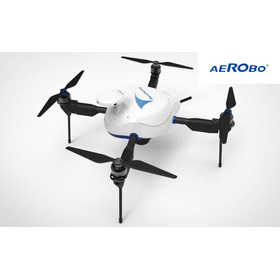
The "AeroBo (AS-MC03)" is a drone suitable for surveying and inspection using photographs taken from the sky. It is equipped with a high-performance camera that can achieve high image quality even with a fast shutter speed, as well as a high-sensitivity image sensor. Additionally, it features a mechanical shutter mechanism that minimizes image distortion, enabling high-precision and reliable drone surveying. 【Features of AeroBo (AS-MC03)】 ■ High-performance camera with an APS-C size image sensor and interchangeable lenses, ideal for surveying ■ Automation of camera and route settings compliant with I-Construction standards ■ Robust for on-site operations, with waterproof, dustproof, and wind-resistant capabilities *For more details, please refer to the PDF document or feel free to contact us.

  • others
  • Survey drone

Added to bookmarks

Bookmarks list

Bookmark has been removed

Bookmarks list

You can't add any more bookmarks

By registering as a member, you can increase the number of bookmarks you can save and organize them with labels.

Free membership registration

Features of the Build Flyer: Long flight time

It has been designed to be useful for time-consuming tasks such as inspections and surveys!

The "Build Flyer" is a surveying and aerial photography drone capable of long-duration flights. It features a thorough reduction in airframe weight, optimized thrust efficiency, and is equipped with a large-capacity battery. It can be utilized for time-consuming tasks such as wind power inspection, laser surveying, photogrammetry, and disaster site investigations. 【Features】 ■ Payload: 5kg - 25 minutes of continuous flight ■ No load: 45 minutes of continuous flight ■ Battery capacity (mAh): 22,000 x 2 ■ Thorough reduction in airframe weight / Optimized thrust efficiency / Equipped with a large-capacity battery ■ Performance suitable for time-consuming tasks such as inspections and surveying *For more details, please refer to the PDF document or feel free to contact us.

  • Other measurement, recording and measuring instruments
  • Survey drone

Added to bookmarks

Bookmarks list

Bookmark has been removed

Bookmarks list

You can't add any more bookmarks

By registering as a member, you can increase the number of bookmarks you can save and organize them with labels.

Free membership registration

Application: Surveying and Aerial Photography Drone "Build Flyer"

For those who want to observe the same thing regularly: Introduction to features suitable for surveying and aerial photography, such as 'autonomous flight' and 'home return function'.

Introducing the application of the "Build Flyer," a drone for surveying and aerial photography. In automatic navigation, it is possible to instruct the drone to sequentially follow specific points along a designated route. You can also specify actions such as takeoff and landing at points, hovering, and triggering the camera shutter, allowing for flights suitable for surveying and aerial photography. Additionally, it features a home return function, automatic takeoff and landing capabilities, and fail-safe functions. 【Applications】 ■ Automatic navigation ■ Home return function ■ Automatic takeoff and landing function ■ Fail-safe function (when battery level reaches 30%, the legs enter landing mode and the drone automatically returns home) *For more details, please refer to the PDF document or feel free to contact us.

  • Other measurement, recording and measuring instruments
  • Survey drone

Added to bookmarks

Bookmarks list

Bookmark has been removed

Bookmarks list

You can't add any more bookmarks

By registering as a member, you can increase the number of bookmarks you can save and organize them with labels.

Free membership registration

JC-STAR★1 compatible | Domestic photogrammetry drone "AeroBo PPK"

Supports dual-frequency GNSS and PPK positioning. A domestically produced photogrammetry drone that combines long-distance communication and convenience.

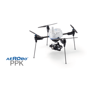
The "AeroRob PPK (AS-MC03-PPKHL)" is a domestically produced photogrammetry drone equipped with a dual-frequency GNSS receiver, supporting post-processed kinematic (PPK) positioning. By accurately calculating the camera position at the time of shooting through PPK positioning, it reduces the need for establishing and surveying control points, thereby streamlining fieldwork in photogrammetry. It is equipped with a Sony α6100 and a 3-axis gimbal. With the adoption of Herelink HD Transmission, it allows for flying while checking the drone camera's footage on a handheld control device, and it supports still image capture from any angle. By combining it with the GNSS ground marker "AeroRob Marker" and the photogrammetry analysis and data management system "AeroRob Cloud," it can streamline operations from aerial photography, PPK positioning, image analysis, to deliverable creation. Additionally, it has obtained the "JC-STAR Compliance Label★1," which visualizes security measures for IoT products. This can be used as information to verify compliance with security requirements when introducing or procuring commercial drones.

  • 3D measuring device
  • Image analysis software
  • Survey drone

Added to bookmarks

Bookmarks list

Bookmark has been removed

Bookmarks list

You can't add any more bookmarks

By registering as a member, you can increase the number of bookmarks you can save and organize them with labels.

Free membership registration

Ishikawa Energy Research's 【Build Flyer】

Domestic development and manufacturing with peace of mind and trust. Thorough pursuit of customer "peace of mind and safety." "High-quality products that are safe for a long time."

The "Build Flyer" is a surveying and aerial photography drone that enhances trust and precision, achieving tough flights. By incorporating an ESC, it improves heat dissipation and protects the ESC. By using lightweight magnesium, which is a practical metal, the strength, rigidity, and weather resistance have been significantly increased. ■ No load: 45 minutes; Maximum payload 5kg: 25 minutes ■ Equipped with two 22000mAh batteries for long flight times with high capacity and energy density ■ Utilizes magnesium alloy for lightweight, high durability, and high rigidity ■ Features a high-performance flight controller, Pixhawk ■ Aircraft with excellent dust and water resistance (IP23) suitable for flying in rainy conditions ■ Legs can be raised horizontally for extensive shooting capabilities ■ Compact transport with foldable arms *For more details, please refer to the PDF document or feel free to contact us.

  • Other industrial robots
  • others
  • Other measurement, recording and measuring instruments
  • Survey drone

Added to bookmarks

Bookmarks list

Bookmark has been removed

Bookmarks list

You can't add any more bookmarks

By registering as a member, you can increase the number of bookmarks you can save and organize them with labels.

Free membership registration